Notice to Mariners No 75 of 2024
Friday, 22 November 2024
HARBORS AND NAVIGATION ACT 1993
Notice to Mariners No. 75 of 2024
SOUTH AUSTRALIA – SPENCER GULF – WALLAROO BAY– NEW PORT AND HARBOR – NARUNGGA - INCLUDING 2 x NEW TRANSHIPMENT POINTS
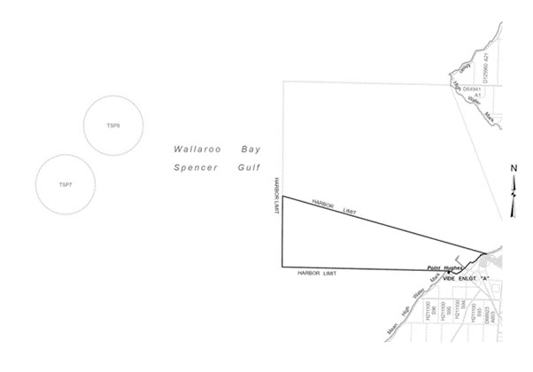
Mariners are advised that a new Port and Harbor, Port Narungga has been declared on the East coast of Yorke Peninsula at Wallaroo Bay within the Spencer Gulf.
The Port of Narungga and Harbor area is as follows:
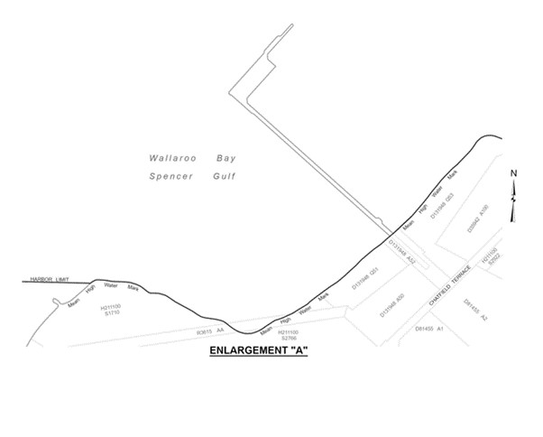
The subjacent land underlying, and the adjacent land extending from, the waters, rivers, creeks, and inlets to the High-Water Mark of that part of Wallaroo Bay bounded as follows.
Commencing at a point on the High Water Mark at longitude 137°36’04.71" East and the northern extremity of Point Hughes, then westerly for 3 nautical miles to latitude 33°56'07.41" South, longitude 137°32'30.69" East, then northerly to latitude 33°54'50.72" South, longitude 137°32'29.20" East, then generally south easterly for 3.8 nautical miles to a point on the High Water Mark at longitude 137°36'55.68" East, then generally south westerly along the High Water Mark back to the point of commencement.
To the West of the port boundary 2 transhipment points have been established, these are TP7 and TP8 and have been declared as follows:
TP7 transhipment point in Spencer Gulf:
33°54'44" S 137°27'48" E
TP8 transhipment point in Spencer Gulf:
33°53′39" S 137°28'48" E
Vessels are prohibited from entering or remaining in waters within 0.5 nautical miles of a vessel (the loading vessel) while the loading vessel is, or is about to be, engaged in transhipping at TP7 or TP8.
The distance referred to is to be measured from each point of the outer edge of the loading vessel or any anchor, buoy or other equipment deployed from the loading vessel.
Mariners are advised to navigate with caution when transiting the area.
Charts affected:
Aus 777
Aus 778
Aus 485


GORDON PANTON
Manager Marine Safety and Compliance
Department for Infrastructure and Transport
22 November 2024
DIT 2017/02277/01
www.marinesafety.sa.gov.au


